About the Oban Nature Network project
who is leading the project?
Oban Community Council are the lead organisation, with support from other local groups.
what are we trying to do?
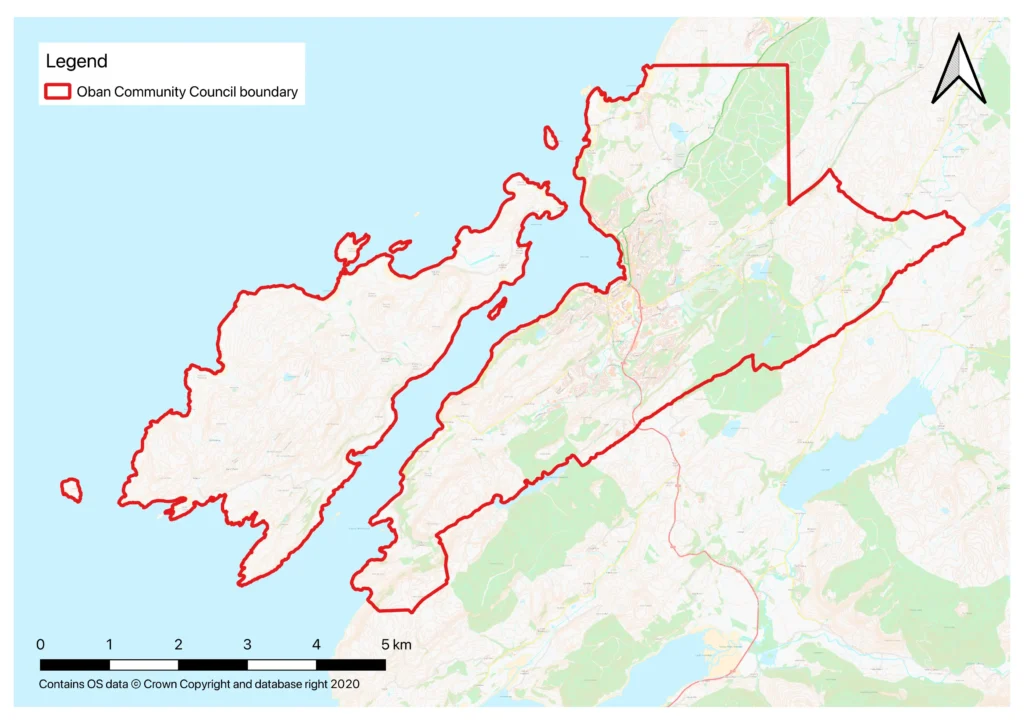
By mapping natural spaces in and around Oban we can identify key areas for future protection and management. The ultimate goal is to create a healthy, connected, more resilient mosaic of habitats for the benefit of all nature and humans alike. The whole of the Oban Community Council area will be included – see map at bottom of page.
what is a Nature Network?
It is a project to restore and connect fragmented habitats, allowing wildlife to move between them and ecosystems to recover. These networks aim to halt biodiversity loss and help adapt to climate change. Every local authority is required to have a Nature Network in place by 2030 and the work that we will be doing in Oban will be submitted to A&BC to be included in their work. Many of the areas that are important to wildlife are also green spaces that local residents use and value. It is an opportunity for us locally to have more input and control over the process and to protect the areas that matter most to us.
why is this needed?
In our local area we have a wide variety of habitats from peat bog to beach, from temperate rainforest to freshwater habitats. These support an impressive diversity of nationally and globally rare species. But many of these habitats are in poor condition, are threatened by invasive species or are fragmented, preventing species from spreading easily.
Local groups such as Argyll Biological Records Centre (ABReC) , Lorn Natural History Group (LNHG) & Keep Oban Beautiful have long been aware of the high value of the natural spaces in and around Oban but there has not been a mechanism to report, monitor or highlight this to a relevant local body nor to the community itself.
Through initial consultation activities, the Community Council has heard, almost unanimously, that the community desires stronger protection for these habitats & species and there is frustration that our natural resources are not protected.
The lives of many local residents are enriched daily by sightings of any number of endangered species such as red squirrels, pine marten, dragonflies, lichens etc. and access to green spaces in and around the town.
how will we do it?
The first stage in January and February 2026 will be an initial review of aerial photography and maps to identify areas of interest.
This will lead into ground truthing activity, from Spring 2026, which will be carried out with the support of Argyll Biological Records Centre (ABReC) and Lorn Natural History Group (LNHG), their members plus members of the community.
During this phase the main existing habitats across the network will be described and any threats to the habitats identified. Known threats include the presence of Invasive Non-Native Species (INNS), a lack of regrowth/young trees in wooded areas, fragmentation & drainage of peat bogs.
Where possible the threats will be quantified, and solutions or opportunities suggested. This will also include mapping the upper limits of invasive species such as Japanese knot weed & skunk cabbage along watercourses.
can I get involved?
Yes! We will be asking local residents to share their sightings of specific indicator species such as red squirrels, bats, newts & butterflies and to report areas they believe to be of high conservation value.
We’ll also be keen for volunteers to help us in the work on the ground to identify habitats and species. This will be an opportunity for residents to share their local knowledge, to really get to know their neighbourhood and also to learn from the collective wisdom of local experts.
We will be making simple ID guides and resources available digitally and in print form to help with this. You do not need to be an expert to contribute.
how will we keep residents up to date with the project?
There will be regular updates to this website, plus our facebook page. We will also be sharing information through social media and printed media.
what will the end result be?
The final report and maps will be presented to Oban Community Council and Argyll & Bute Council in December 2026 and made available to the public. The report will inform planning and could be incorporated into the Local Development Plan.
This work will inform future habitat and species regeneration projects, control of INNS and the connection of fragments of important habitats, species and green/blue spaces.
Records and data gathered will also be passed to Argyll Biological Record Centre to be submitted to the NBN Atlas where it will be publicly available and will inform future planning and development in the area, and be accessible to other organisations and the general public.